Colorado’s Geologic Framework
Understand the basement rocks, uplifts, volcanic centers, batholiths, and mineral belt that control Colorado deposits.
By the end of this module
- Recognize Colorado’s major geologic provinces
- Connect rock age to likely mineralization
- Understand the Colorado Mineral Belt
Stand on the summit of a Front Range fourteener and look down at the rock under your boots. There’s a good chance you’re standing on something older than complex life on Earth — a chunk of continent that was already ancient when the dinosaurs showed up, later shoved a couple of miles skyward, then partly buried in its own volcanic debris. Understanding why Colorado’s rock is arranged the way it is turns every roadcut and ridge into a readable story, and it tells you where to actually point your pan.
The Precambrian Basement — Colorado’s Ancient Foundation
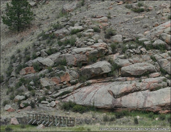
Colorado’s oldest rocks are roughly 1.4 to 1.8+ billion years old, forming a crystalline basement of metamorphic and igneous rock — gneiss, schist, granite — exposed extensively in the cores of the Front Range, the Sawatch Range, and other major ranges. The USGS has published a preliminary Precambrian basement map documenting this ancient foundation across the state (USGS Open-File Report 2001).
This basement matters to prospectors for one big reason: it’s the host rock for many of the hydrothermal veins that built Colorado’s historic mining districts. When you’re standing on exposed Precambrian gneiss or schist, you’re looking at rock old enough and structurally complex enough to have hosted multiple generations of mineralizing fluids over a billion-plus years.
The Laramide Orogeny — How the Mountains Got Here
The Southern Rocky Mountains, including essentially all of Colorado’s major ranges, were built during the Laramide orogeny, roughly Late Cretaceous through early Tertiary time (about 70–40 million years ago). This wasn’t new mountains erupting from volcanic material — it was basement-cored deformation: existing ancient Precambrian rock was faulted and folded upward as a rigid block. The leading model attributes this to shallow ("flat-slab") subduction of the Farallon oceanic plate beneath western North America, which transmitted stress far inland instead of staying confined to the coast (academic modeling study, ADS).
That’s why Colorado’s high peaks so often expose ancient crystalline rock at their summits — you’re seeing basement rock that was thrust upward, not younger material piled on top.
Volcanic Centers and Calderas — The San Juan Story
After Laramide uplift settled down, Colorado went through a dramatic mid-Tertiary volcanic phase, concentrated heavily in the San Juan Mountains, which today form the largest erosional remnant of a composite volcanic field that once covered much of the southern Rockies.
The sequence: central-volcano eruptions (roughly 35–30 million years ago, producing the Conejos Formation) were followed by enormous ash-flow eruptions sourced from calderas. In the central San Juans, at least 8,800 cubic kilometers of dacitic-to-rhyolitic magma erupted as nine major ash-flow sheets between about 28.3 and 26.5 million years ago, from calderas ranging 10 to 75 kilometers across (USGS Professional Publication description).
This volcanic field is the direct geologic ancestor of the historic gold and silver districts around Silverton, Lake City, and Creede — the mineralizing systems that built those districts are tied to the same magmatic plumbing that produced the ash-flow eruptions.
The Pikes Peak Batholith
Pikes Peak Granite, roughly 1.08 billion years old, forms a large intrusive body at the core of Pikes Peak and the surrounding region. It’s a classic, easily observed Precambrian granite — coarse pink-to-red crystals you can spot from the road — and its associated pegmatites are the source of gem-quality amazonite and smoky quartz that draw rockhounds to the Pikes Peak region.
The Colorado Mineral Belt — The Backbone of Colorado Mining
If you remember one geographic feature from this module, make it this one. The Colorado Mineral Belt is an elongate, northeast-trending zone of hydrothermal mineral deposits running from the San Juan Mountains in southwest Colorado to the eastern Front Range northwest of Denver.
Key characteristics:
- Contains felsic-to-intermediate intrusive and volcanic rocks ranging from Late Cretaceous to late Tertiary age.
- Coincides with a pronounced gravity low, attributed to a buried, low-density batholith whose apex sits within a few thousand feet of the surface and extends to roughly 40,000 feet depth, spanning 15–20 miles wide.
- Cuts across older Precambrian (Proterozoic) shear zones, which likely provided pre-existing crustal weaknesses that localized later igneous intrusion and mineralization (USGS Open-File Report 96-082).
Deposit types found along the belt include stockwork molybdenum (Henderson and Climax-type deposits), porphyry copper, and polymetallic veins carrying copper, molybdenum, lead, zinc, silver, gold, and tungsten.
Nearly every major historic hardrock district in Colorado sits on or near this belt:
| District | General location |
|---|---|
| Central City / Idaho Springs | Front Range, Clear Creek County |
| Leadville | Sawatch Range, Lake County |
| Breckenridge | Summit County |
| Aspen | Pitkin County |
| Silverton | San Juan Mountains |
Putting It Together: Reading the Regional Story
| Geologic feature | Approximate age | What it tells a prospector |
|---|---|---|
| Precambrian basement | 1.4–1.8+ billion years | Ancient host rock; potential for old, structurally complex vein systems |
| Laramide uplift | ~70–40 million years ago | Explains why old basement rock is exposed at high elevation today |
| San Juan volcanic field | ~35–26.5 million years ago | Source of the Silverton/Lake City/Creede mineralizing systems |
| Pikes Peak batholith | ~1.08 billion years | Distinct granite body; pegmatite gem source, not a base-metal vein target |
| Colorado Mineral Belt | Late Cretaceous–late Tertiary intrusions | The single best predictor of where historic districts cluster |
Myth Check: “Old Rock” Doesn’t Automatically Mean “Mineralized Rock”
It’s tempting to assume any billion-year-old outcrop is loaded with potential. In reality, the Precambrian basement is mineralized only where later igneous activity — like the intrusions along the Mineral Belt — injected hydrothermal fluids into it. Plenty of ancient basement rock across Colorado never got that treatment and is geologically unremarkable for hardrock exploration. Age alone is not a green light; you need the overprint of later mineralizing events, which is exactly why the Mineral Belt is a map feature, not the whole state.
Common Mistakes
- Confusing “old rock” with “valuable rock." As above — mineralization requires the right later-stage overprint, not just age.
- Assuming volcanic country means the whole area is a caldera. Calderas are discrete, mappable features tens of kilometers across, not a description of an entire mountain range.
- Ignoring the Mineral Belt’s actual trend. It’s a specific northeast-trending corridor — a prospect far outside that trend needs its own independent geologic justification, not an assumption of “well, it’s Colorado.”
- Treating the Pikes Peak batholith like a base-metal target. It’s a granite/pegmatite system associated with gem minerals, not the polymetallic vein style found along the Mineral Belt proper.
Field Exercise
Pull up a Colorado state geologic map or the Colorado Geological Survey’s online map viewer (Module 8 will cover this tool in detail). Trace the Colorado Mineral Belt from the San Juans to the Front Range, and mark three historic districts it passes through. For each district, note: Is it closer to a caldera-related volcanic center, or to a discrete batholith/pluton? Write one sentence per district explaining which of this module’s geologic features is most likely responsible for its mineralization.